
MAJOR FEATURES OF THE EARTH'S SURFACE
Meaning of a Continent
Explain the meaning of a continent
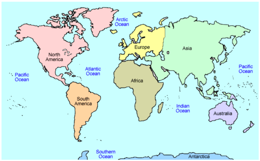
The land surface occupies 29% of the surface of the globe, and the remaining 71% is covered by water. The land surface forms seven continents. A continent is a major landmass rising from the ocean floor. It includes islands adjacent to the continent. There are seven continents namely, Africa, Asia, South America, North America, Europe, Australia and Antarctica. These continents are surrounded by the following oceans: The Indian Ocean, the Atlantic Ocean, the Pacific Ocean, the Arctic Ocean and the Southern ocean.
There is more land surface in the northern hemisphere than in the southern hemisphere but there is more water surface in the southern hemisphere than in the northern hemisphere. The continents are broader in the northern hemisphere. The seven continents that make up the globe are explained below:
- Australia: Australia is the smallest continent and it is about a quarter of the size of Africa. Its size is about 8.5 million square kilometres. Australia is approximately 10°S and 40°S and between 115°E and 150°E. The islands of New Zealand to the south east of Australia are part of this continent. The continent is bordered to the west and north by the Indian Ocean, to the east by the Pacific Ocean, and to the south by the Southern Ocean.
- Europe: Europe is the sixth continent in size and it is about two-fifth the size of Africa. The size of Europe is 9.8 million square kilometres. Most of Europe lies between 40°N and the 1 Arctic circle, and between 10°W and 60°E. It lies to the west of Asia, separated by the Ural Mountains. Europe is bordered to the north by the Arctic Ocean, to the west by the Atlantic Ocean, and to the south by the Mediterranean Sea.
- Antarctica: Antarctica is the fifth continent in size and it is about one-third the size of Africa. Its area is about 11.4 million square kilometres. This is the southernmost continent, forming a circle at the South Pole and extends south of 661⁄2°S. It is surrounded by the southern ocean. The continent is mostly uninhabited.
- North America: North America is the fourth continent in size and it is slightly more than half the size of Africa. Its size is about 17.9 million square kilometres. If extends from 10°N to 65°N and from 60°W to 160°W. It is bordered to the west by the Pacific Ocean, to the East by the Atlantic Ocean, and the North by the Arctic Ocean.
- South America: South America is the third largest continent and it is about two-thirds the size of Africa. Its size is about 24.3 million square kilometres. It lies between 10°N and 50°S and between 35°W and 80°W. This continent is bordered to the east by the Atlantic Ocean, to the West by the Pacific Ocean, and it is joined to North America by the Isthmus of Panama.
- Africa: Africa is the second largest continent with an area of about 3.6 square kilometres. Africa extends from 37°N to 35°S and from 50°W to 50°E and it is crossed by Tropics of Cancer and Capricorn. Thus the greater part, about three quarters of the whole area lies in the tropics. Africa is bordered to the north by the Mediterranean Sea, to the west by the Atlantic Ocean, and to the East by the Indian Ocean.
- Asia: Asia is the largest of all continents. It covers more than one third of the land surface of the earth. It is approximately one and a half times the size of Africa. Its total area is about 45.6 million square kilometres. Asia stretches from 0° to 67°N and from 30°E to about 18°E. The Ural Mountains form the boundary between Asia and Europe. This continent is attached to Africa by the narrow Isthmus of Suez which has been dug to form the Suez Canal. The continent is bordered to the North by the Arctic Ocean, to the East by the Pacific Ocean, and to the South by the Indian Ocean.
The following table summarizes the location and area of all seven continents discussed above:
| Continent | Geographical location | Area (Million Km2) |
| Asia | 0° - 67° N; 30° - 180° E | 45.6 |
| Africa | 37° N - 55° S; 15° W - 50° E | 30.6 |
| South America | 10° N - 50° S; 35° W - 80° W | 24.3 |
| North America | 10° N - 65° N; 60° W - 160° W | 17.9 |
| Antarctica | Between the South Pole and 66½ °S | 11.4 |
| Europe | 40° N and the Arctic Circle ; 10° W - 60° E | 9.8 |
| Australia | 10° S - 40° S; 115° E - 150° E | 8.5 |
Major Features of the Continent
Identify the major features of the continent
The surface of the continents is not smooth. It has mountains, hills, rivers and valleys, plateaus, and plains. Mountains are landforms which have high relief generally over 300 metres above the surrounding area. Hills are landforms that have moderate relief generally between 150 and 300 metres above the surrounding area. Plateaus are extensivehighland areas with more or less uniform summit level, bounded by one or more slopes falling steeply away, sometimes rising on one or more sides by steep slopes to mountain ridges. Plains are continuous sketches of comparatively flat land not much above sea level, sometimes gently rolling or undulating.
Mountains
There are four types of mountains. These are the Fold Mountains, Block Mountains, Residual Mountains, and Volcanic Mountains. These mountains are all named according to the way they were formed.
- Fold Mountains:Fold Mountains are formed by wrinkling or (folding) of the Earth’s crust. Fold Mountains usually form parallel ranges which extend for hundreds of miles across a continent. Thus, Fold Mountains are the most extensive ranges in the world. For example, the Rocky Mountains in North America vary in width from 640 to 1,600 kilometres and are about 5,000 kilometres in length. These types of mountains have some of the highest peaks in the world. Mount Everest in the Himalayas is 8,848 metres above sea level and the Aconcagua in the Andes is 7,003 metres above sea level. Examples of Fold Mountains include the Himalayas in Asia; the Rockies in North America; the Andes in South America; the Alps in Europe; the Atlas in North Africa; the Cape ranges in South Africa; the Appalachians in the USA; and the Great Dividing Ranges in Australia.
- Block Mountains:Block Mountains are formed when a movement in the earth’s crust forces the rocks to break instead of folding. As a result enormous cracks or faults are formed. When two sets of faults run parallel to each other and the ground between is forced to rise up, a block (fault) mountain is formed. Usually Block Mountains do not extend over wide areas as Fold Mountains do. Examples of Block Mountains are the Usambara, Uluguru and Ruwenzori Mountains in Africa; the Vosges and Black Forest Mountains in Europe; and Mount Sinai in Asia.
- Residual Mountains:Residual mountains are formed when an area of highland remains standing above the general level of land after the rivers and other natural agents have lowered the surface of the surrounding area. Sometimes such highlands are called mountains of denudation. These mountains may in some cases appear as isolated hills but in other cases they appear as long ridges, generally steep on one side (the scarp slope) and gentle on the other side (dip slope). Examples of residual mountains are the Ahaggar Mountains of central Sahara; the Sekenke hills of Singida in Tanzania; the Admawa mountains of eastern Nigeria; the Highlands of Scotland; the Sierras of central Spain; and the Mesas and Buttes of the western plateau of the United States.
- Volcanic Mountains:Volcanic mountains are formed from the piling up and cooling of hot molten lava and ashes that are thrown out from the earth’s interior after a volcanic eruption. Some of the volcanic mountains existing today were built up by a single eruption, but others were built by several eruptions. Volcanic eruptions are still taking place in some parts of the earth. Among the existing volcanic mountains, some still experience periodic eruptions, for example, the Vesuvius in Italy; the Krakatoa in Indonesia; the Mufimbiro in Uganda; and the Oldoinyo-Lengai in Tanzania. The Volcanic Mountains that still experience periodic eruptions are called active volcanic mountains.The Volcanic Mountains which erupted once in historical times and are no longer active are said to be dormant. In this group are included the Kilimanjaro and Meru mountains in Tanzania. Those volcanic mountains which have never experienced eruption and have shown no signs of erupting again are said to be extinct (dead). Included in this group are mountains Kenya, Elgon, Ngorongoro and Rungwe in East Africa; and Demavend in Iran.Volcanic mountains are usually conical in shape and mostly contain craters or depressions at their summits, for example, mountains Fujiyama and Kilimanjaro. Sometimes the craters are filled with water to form crater lakes.
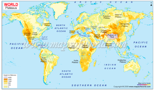
Plateaus
In geology and earth science, a plateau (plural: plateaus or plateaux), also called a high plain or tableland, is an area of highland, usually consisting of relatively flat terrain that is raised significantly above the surrounding area, often with one or more sides with steep slopes.
The largest and highest plateau in the world is the Tibetan Plateau, called the "roof of the world”. The Tibetan plateau covers approximately 2,500,000 km2 at about 5,000 m above sea level.
The second-highest plateau is Deosai National Park (also known as Deoasai Plains) at an average elevation of 4,114 m and is located in the Skardu District of Gilgit-Baltistan, in northern Pakistan.
The third-largest plateau is the Antarctic Plateau, which covers most of central Antarctica, where there are no known mountains, but rather 3,000 m or more of ice.
Other plateaus in the world include the Colorado Plateau (North America); the Great Central Plateau, Ahagger Plateau and Fouta Djallon Plateau (Africa); Brazilian Plateau (South America), Mexican Plateau and Laurentian Plateau (North America); Arabian Plateau, Deccan Plateau and Tibet Plateau (Asia).
Plains
A plain is a broad area of relatively flat land. Plains are one of the major landforms, or types of land, on Earth. They cover more than one-third of the world’s land area. Plains exist on every continent except Antarctica. Plains occur as lowlands and at the bottoms of valleys but also on plateaus or uplands at high elevations.
Plains in many areas are important for agriculture because where the soils were deposited as sediments they may be deep and fertile, and the flatness facilitates mechanization of crop production; or because they support grasslands which provide good pasture for livestock.
Plains vary widely in size. The smallest occupy only a few hectares, whereas the largest cover hundreds of thousands of square kilometres. For example, the Great Plains of North America extends from Pyrenees Range on the French–Spanish border across northern Europe and Asia, almost halfway around the world.
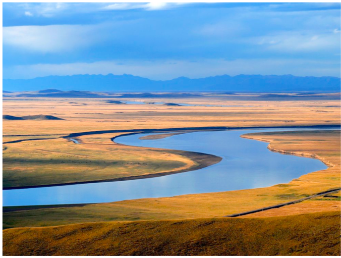
The Yellow River winds through the plains of Sichuan, China. Many rivers are surrounded by plains, or broad areas of flat land.
Meaning of a Water Body
Define a water body
A water body is any significant accumulation of water, generally on a planet's surface. The term most often refers to oceans, seas, and lakes, but it includes smaller pools of water such as ponds, wetlands, or more rarely, puddles. A body of water does not have to be still or contained. Rivers, streams, canals, and other geographical features where water moves from one place to another are also considered water bodies.
Oceans and Other Water Bodies
Identify the oceans and other water bodies
An ocean is defined as a body of saline water covering much of the earth. The largest ocean is the Pacific. Its area is about 165.3 million square kilometres. The second largest ocean is the Atlantic, which covers about 82.2 million square kilometres. The IndianOcean, covering about 73.4 square kilometres is the third largest, followed by the Arctic Ocean, covering about 14.0 million square kilometres.
Composition of ocean water
Ocean water contains a number of dissolved mineral salts. These mineral salts include sodium chloride (common salt) which makes up 78% of all salt in the ocean water; and compounds of magnesium, potassium and calcium. Most of the minerals in the ocean are a result of constant accumulation since the formation of the oceans. However, a small amount of the minerals come from the land, having been dissolved by water and brought into the ocean by rivers. But the mineral salts in rivers are only in very small quantities.
The saltiness of the ocean water is not the same everywhere. Saltiness of the ocean water depends mainly on temperature which affects the amount of salt that can dissolve in the water, the amount of fresh water brought into the ocean by rivers and rainfall, and the amount of evaporation taking place from the surface.
Water temperature
Water is heated by the sun’s rays much more slowly than land is. Water also loses heat to the air around it more slowly than the land does. This causes the temperature of the sea water to vary only slightly from season to season. In general, the temperature of the ocean water decreases from the equator, where the surface temperature is 25°C to the polar regions where the water is very cold (-2.2°C). But the decrease in temperature poleward is not uniform because of the occurrence of warm and cold ocean currents. Onthe other hand, water temperature decreases with depth in the tropics up to the depth where the temperature is 1.1°C.
Water movements
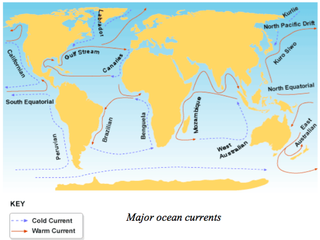
Ocean water is constantly in motion. There are two types of movement. One is horizontal movement, which is in the form of ocean currents and tides, and the other is vertical, which is the rising of subsurface water and the sinking of the surface water. The movements of ocean water are a result of density variations in the water which is particularly important in vertical movements and winds which are particularly important in horizontal movements.
An ocean current is the permanent or seasonal movement of surface water in the ocean. There are warm and cold currents, the ocean currents are set in motion by a combination of prevailing winds, differences in density and temperature of the ocean waters, the rotation of the earth, and the shape of landmass.
Tides are the rising and the falling in the level of water in the oceans, seas and lakes. They occur twice a day (in 24 hours). The level to which tides rise and fall varies from day to day. On the days when it rises to its highest level, it also falls to its lowest level. The rising and falling is caused by the pull of gravity of the moon and the sun.
Waves are to and from movements of the surface water. When water is thrown into waves, its surface gets a shape of ups and downs. The highest part of the wave is called the crest and the lowest the trough. The distance from one crest to the next, or from trough to trough is called the wavelength. Waves travel in some definite direction, andgive the impression that they move forward, but in reality only the shape moves forward while the water moves up and down. For example, a cork thrown into the water does not travel with the waves, it moves up and down and to and fro, but not forwards. A wave is driven on the shore by wind, and its height and force are determined by the strength of the wind and the distance of open water over which it has blown.
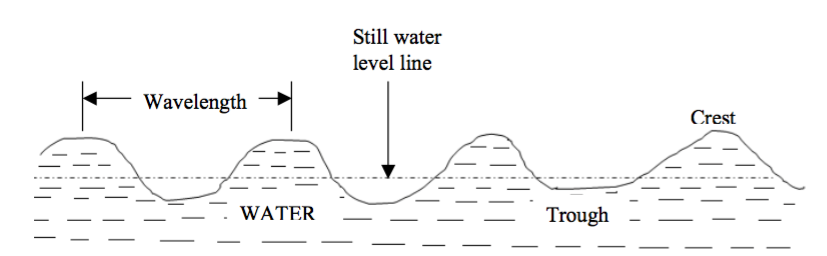
Water waves
Lakes
A lake is a natural or man-made body of water that is surrounded by land. Lakes lie on land and are not part of the ocean, and therefore are distinct from lagoons, and are also larger and deeper than ponds, though there are no official or scientific definitions. Most lakes are fed and drained by rivers and streams.
Some lakes are artificial (man-made lakes) and are constructed for industrial or agricultural use, for hydro-electric power generation or domestic water supply, or for aesthetic or recreational purposes. Examples of man-made lakes include Lake Nasser (in Egypt), Lake Kariba (Zambia), and Lake Volta (Ghana).
The majority of lakes on Earth are fresh water, and most lie in the Northern Hemisphere at higher latitudes. Most lakes have at least one natural outflow in the form of a river or stream, which maintains a lake's average level by allowing the drainage of excess water. However, some lakes do not have a natural outflow and lose water solely by evaporation or underground seepage or both.
Lakes are not evenly distributed on the earth's surface; most are located in high latitudes and mountainous regions. Although lakes are usually thought to be freshwater bodies, many lakes, especially in arid regions, become quite salty because a high rate of evaporation concentrates inflowing salts. The Caspian Sea, Dead Sea, and Great Salt Lake are among the greatest of the world's salty lakes. The Great Lakes of the United States and Canada is the world's largest system of freshwater lakes. Lake Superior alone is the world's largest freshwater lake with an area of 82,414 sq km. The Caspian Sea is the largest lake in the world, with an area of 372,960 sq km. Lake Titicaca in the AndesMountains of South America is the world’s highest lake at 3,800 m above sea level; while the Dead Sea is the lowest at 425 m below sea level.
Rivers
A river is natural water flowing in a definite channel towards an ocean, sea, lake, desert basin, marsh or another river. In some cases, a river flows into the ground and become dry at the end of its course without reaching another body of water. Small rivers can be referred to using names such as stream, creek, brook, rivulet, and rill.
Rivers are part of the hydrological cycle. Water generally collects in a river from precipitation through a drainage basin from surface runoff and other sources such as groundwater, springs, and the release of stored water in natural ice and snowpacks (e.g. from glaciers).
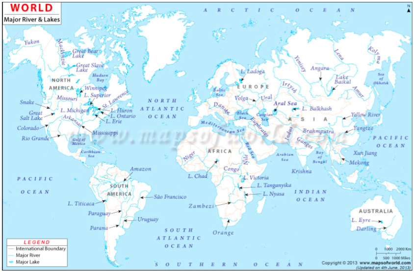
Examples of rivers in Africa include the Nile, Congo, Niger, Zambezi and Orange. In Tanzania we have rivers like Rufiji, Ruvuma, Ruaha, Pangani, Wami and Malagalasi.
Features of the Ocean Floor
Describe the features of the ocean floor
The floor of the ocean is irregular. The major relief features of the ocean floor are explained below:
- Continental shelf:This is a gentle-slope margin of a continent that forms the shallow areas of oceans. These shallow areas extend from the coast to a depth of about 200 metres towards the ocean, and usually end suddenly.
- Continental slope:The continental slope is found at the point where the continental shelf forms a steep slope with the lower slope of the ocean floor towards the sea.
- Ridge:A ridge is the raised part of the ocean floor. Some of these rides appear above the surface of the oceans as oceanic islands.
- Ocean deep or trench:An ocean deep is a long, narrow depression (or trough) found on the ocean floor.
- Deep sea plain (ocean plain):An ocean plain is the most extensive, flat area of the ocean floor. It is a monotonous and undulating area. A large part of the plain is covered by mud.
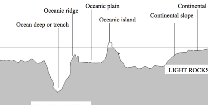
A generalized section across an ocean floor
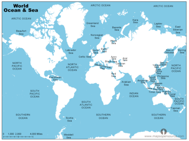
The Map Showing the Distribution of Continents and Water Bodies
Draw the map to show the distribution of continents and water bodies
The Map showing distribution of water bodies.
- READ TOPIC 3: Weather

No comments:
Post a Comment