

1.1 GROUND WATERWATER CYCLE
-Rain falls on the earth surface in filtrates (soaks into) the soil– -Some water flows over the surface as overland flow (run off)–
-Some water lie on the surface as ponds and lakes and some return to the atmosphere as water vapour through evaporation and transpiration.Factors enhancing water cycle1.
1. Nature of the soil and parent rocks2.
2. Steepness of the slopes3.
3. Nature of climate ;- Is a continuous succession of movement, condensation, evaporation, run off, percolation and precipitation
-Water vapour is carried by wind to the land where it is deposit as rain or snow-Movement of water and water vapour form a system called water cycle.


The water within the ground surface covered at the position of the pore space of the soil. A body of water derived from percolation contained in the soil, sub soil and underlying rocks above impermeable.
SOURCES OF GROUND WATER
There are three main sources;
1. 1.Rain formation– Is the source of ground water which existed during the formation of rainfall. It’s providing about 90% of the total water.
2. 2. Rock formation.– During formation of rocks formed with the element of water. The common rocks are sedimentary and igneous rocks.
3. 3. Water bodies.– The water bodies like Ocean, Sea and river influence the development of ground water. The water penetrates from the water bodies.
TYPES OF GROUND WATER
-The ground water categorized according to their sources;1.
1. Meteoric water2. 2.
Juvenile water3.
3. Connate water4.
4. Oceanic water1.
1. METEORIC WATER:– Is the underground water formed due to the influence of rain formation. The rainfall is the only source of meteoric water. (Precipitation)-The type of H2O is re – circulated leading to hydrologic cycle.
2. 2. JUVENILE WATER– Is the ground water influence by igneous rocks during the formation of igneous rocks formed with the element of water.Most of the juvenile water contain a lot of minerals like fluoride mineral and also are super heated water (hot spring)
3. CONNATE WATER– Is the ground water formed after the formation of sedimentary rock during the formation of sedimentary rocks formed with the element of water (cold spring)– H2O is usually salty originate from ancient seas
4. OCEANIC WATER– Is the ground water formed from the water bodies. Their sources are river, lake and ocean water penetrates from the water bodies.
METHODS OF OBTAINING GROUND WATER.
Ø Percolation.– Is the rapid penetration of water within the ground surface. This existed when there are availability of joint /cracks /fault on the land surfaceØ Infiltration /filtration.-Is the penetration of water within the ground surface in very slow motion. The water penetrates through natural space (pore space)
FACTORS AFFECTING GROUND WATERè
-Are that factor influence the variation of ground water. The common factor are;
1. CLIMATIC CONDITION.– In desert area there is poor concentration of ground water due to increase in evaporation caused by high temperature.– In equatorial and tropical region there is high concentration of ground water and this is due to heavy rainfall.ii.
2. RELIEF / ANGLE OF SLOPE> -Is the actually appearance of the landscape> -Steep sided area, there is low concentration of ground water since the water is moving down the slope.> -Gentle slope (plain) there is large concentration of ground water (free penetration of water) since the speed of water has decreased.
3. NUMBER OF WATER BODIES-E.g. lakes, ocean, rivers– Availability of water bodies bring about the availability of ground water.
4. AMOUNT OF VEGETATION COVER-Presences of vegetable bring about the availability of ground water since vegetation help in the formation of rainfall.-Absence of vegetation brings about the unavailability of ground water.
5. NATURE/PERMEABILITY OF ROCKS– -Permeable rocks are rocks which allow free penetration of water downward.– -Impermeable rocks are rock which do not allow free movement/penetration of water
– -Primary permeability (porosity) result from open texture, pores
– -Secondary permeability (previous) result from joint and cracks.SATURATION ZONE-Are those layers within the ground surface which contain the element of water. These zones either are permanent or seasonal.TYPES OF SATURATION ZONE1. 1. Non – saturated zone2. 2. Seasonal saturated zone3. 3. Permanent saturated zone
4.Impermeable rocks

1. NON – SATURATED ZONE– Is the part within the ground surface which is not containing the element of water. / It is layers immediately below the surface. It allows H2O to pass through.
2. SEASONAL SATURATED ZONE-Is the part within the ground surface which containing water periodically.-This layer lies immediately below the non – saturated zone. Also known as intermittent saturation-This layer can dry out after a period of drought.
3. PERMANENT SATURATED ZONE.– Is the part within the ground surface which cover with water through out. This layer extends as far down as the impermeable layer, forming the limit to down ward percolation.
AQUIFER/TABLE –Is the beds which allow water to pass through it and is under lain by an impermeable stratum (rock) forming / becoming water – holding.AQUICULTURE-Rock mass /layer that prevent the movement of ground water.
4. IMPERMEABLE ROCKS.-Is a rock which its zone does not allow free penetration of water.A. A: ARTESIAN BASIN.– Is the position on the ground surface /landscape which contain the element of water. This slows the element of existence of ground water.– An artesian basin is basins which consist of a layer of permeable rock lying between two layers of impermeable rocks.Condition for presence of artesian welli. Climate condition – Rainfall availabilityii. Angle of the slope
–Depression /gentle sidediii. Amount of vegetation cover should be
availabilityiv. Presence of water bodiesv. Presence of a layer of
permeable rock lying between 2 impermeable rock· B. WELL– Is a hole /
hollow sunk in the ground up to bellow the water table. This is either
natural or man made.


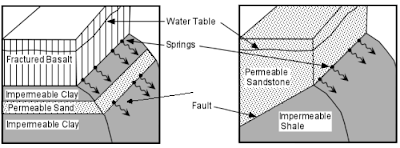
Ways in which spring can be formed (types)

Spring can occur where the rock are well jointed water enter the rock via joint frequently occur where water table meet the surface.

The impounding of water by a dyke whereby it cuts across the layer of permeable rock then the water on the up – slope sided of the dyke is impounded. Water table rises and gives rise to spring where it meets the surface.


-Gently sloping layers of alternate permeable and impermeable rocks rain falling on exposed ends of permeable rocks are socked in the sloping bedding planes and finally comes out as spring are sometimes in line
HOT SPRING
-Is the out flowing of super heated water from the ground surface this involves the heated water.-The hot spring develop from the juvenile water (ground water force during the formation of igneous rocks)CONDITIONS.-Refer to the condition of spring.-The pressure of heat and pressure within the interior of the earth crust
Importance/Effect of ground waterWater from wells may be used for irrigation in the dry area in Sahara; agriculture is practiced around the oases.Spring form a major source of water for both domestic and industrial use.Site of settlement in many regions of the world.Formation of hot spring and geyser on areas with volcanic influence, likely to be a touristWater for cattle ranches Kansas in North AmericaInfluence land slidesDestruction of mineralReappearance at a new sight.Karst processes factor and resulting process.–
KARST SCENERY
KarstIs the landscape formed from the dissolution of soluble rocks including limestone, dolomite and gypsum.Rain water become acidic as it comes in contact with carbon dioxide in the atmosphere and the soil. As it drains into fractures in the rock, the water begins to dissolve away the rock creating a network of passage overtime, water flowing through the network continues to the passage.(CaCo3) + (Co3 ) -> Ca (HCo3 )2Karst Topography– A form of land form denudation base almost exclusively on carbonation (chemical weathering).Factors for the formation of karst region.i. The outcrop should be hard, previous and well jointedii. The climate of the area should be humid. The climate found in e.g. temperate region.iii. The water table should be deep enough to allow percolation of water.Major characteristics of karst sceneryAbsence of surface drainage.Outcrop of bare, rugged rock and steep sided dry valleyNumerous solution depression and residual hills of various sizesA subterranean network of caverns and water coursesJoint are at right angle to each otherLIMESTONE
Is a rock consisting of at least 80% calcium carbonate./is a well-joint rock and its joint and bedding plane soon become opened up by rain water that fall on its surface./is an organic sedimentary rock formed by remains of tiny shells and micro – skeletons deposited on the sea bed.Carboniferous limestone.-Formed from the remains of organic matters usually sea shells and plant, coral.Characteristic of carboniferous limestone
- It is hard, sedimentary rock with a large number of joint (vertical cracks ) and bedding planes (horizontal planes )
- Main process which affect it are carbonation and solution
Landforms in Karst region
-The land form in Karst region are divided into two
1. Surface feature
2. Subterranean/under ground feature
1.SURFACE FEATURES
·Limestone pavement.
-Is a bare rock surface crisis – crossed by numerous gullies where solution has worked along the joint – these are areas of exposed limestone.
Land form in karst regions.
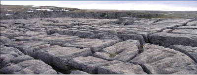
Example of limestone pavementGrikes.
Are deep irregular grooves(gullies) formed when water erode the crack when running on the surface before disappearing underground.
Clints.
are ridge/blocks on the limestone rock separating the grikes.
Swallow holes (sink holes) – This is a vertical hole leading to an underground cave system which is produced when the joint are in large by water percolating into the rock. The running water may sink down through the swallow hole.

Doline -Is a shallow depression /hollow with gently sloping side and generally circular or oval in plan.
– They originate from water percolating underground at the intersection of major joints.
– When swallow holes join together form a large depression called doline.

Uvala-Is a large closed depression with diameter general greater than 500m.It is formed by coalescence/joining of several do lines. The floor is often hummocky consist of several interconnected hollows.
Example of Uvala

Polje:– This is a very large/shallow steep-sided depression with a generally flat floor.– It may be many kilometer in size. The flat floor is often emphasized by the deposition of Terra rossa a red clay material which form an impermeable layer and leads to flooding after heavy rains.-Is a very large depression which is formed when several uvalas collapse, the collapse can be due to faulting some poljes even have small lakes.

Dry valley
-Is a valley with no permanent stream and often with steeps almost vertical sides.– Most are caused by gradual lowering of the water table which itself is often due to the entrenchment of major stream into the limestone. As the water table falls, small stream become intermittent first and finally vanish.Limestone gorge– This is the deep steps sided valley formed by a large river with its head waters beyond the limestone area steadily entrenching itself into the land surface. The steeps cross profile is partly a result of the nature of rock jointing, formed when roof of a cave collapses inwards. E.g. cheddar

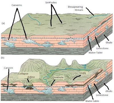
- SUBTERRANEAN FEATURES:
-These are feature formed below the surface
.

– Calcite is deposited through evaporation and when carbon dioxide is released from water.
Below is an example of Stalactites

Example of Karst region in the world
- Karsts region in Yugoslavia
- Causes region in south west France
- Kentucky plateau in U .S .A
- Ambon – Tanga
5. D R C6. Morocco –atlas region7. Madagascar.Economic importance of karst regions:
- Used for / as a tourist attraction hence brings foreign currency to the country e.g. Ambon caves in Tanga.
- Karstified limestone act as an aquifer where water can be store underground and later extract by human e.g. in Texas
- Create complex underground water flow network and large causes enough for human access.
- Limestone is an important rock that is used in building and for making cement e.g. sokoto, ewekoro in Nigeria
- Sufficient pasture to support goals sheep and cattle but not good for activation since the soil is poor an
1.2 LAKES
Is a hollow of which they vary in different size .Some lakes are natural and other are temporary.
Therefore a lake as a hollow which is filled with water coming from natural sources. A lake can be in liquid or in solid or (glaciers) and it can consist of fresh water or salt water. A lake can be formed from different natural forces and is named after that force together with its size (lake size).The sources of water in the lake is from(i) On the surface (e.g. run off, ice melting)(ii) Underground source (e.g carst region)(iii) From the atmosphere (rainfall)CLASSIFICATION OF LAKESLakes are classified according to the different criteria as follows:
- Due to earth movement lakes can be formed from folding, warping (especially down warping) and faulting.
- Due to erosion we have lakes which are formed by the wind and graciation.
- Due to deposition there are lakes which are formed due to oxbow and delta.
- Due to volcanicity there are rocks which are formed due to crater, lava blocked and lava subsidence.
- And those which are formed due to different types are solution lakes , mining, ponds and dam.
- EARTH MOVEMENT
Folding: Folding lakes can be formed due to compression force .And in young rocks with large piece of rock subsidence occur or down warping.


2. EROSION
There are lakes which are formed due to erosion especially by wind and glacial.
By wind: Blocks and when it is strong wind it lead to the drug of blocks of rocks and form depression (oasis). This lead to the creation of lakes especially when the depression reach the water table .
Then when the depression reach the water table is exposed to the surface .It reate the rocks and sometimes underground streams can be opened.
Also by wind can form Playas.Playas are holes which are drugged by the wind.But they are dry and sometimes can contain fresh water and salty water.
By Glaciation:Lake can be formed by glacier erosion when evalanche moving from the Highlands they come and being deposited on the law land especially when they meet the obstacle and prevented.In this sense they may form glacier lake or in melting they form fresh lakes.They called basin rocks especially when they meet an obstacle.Example lake Teleki-Cirque(corrie)lake .Trough lakes(Ribbon lake or tinger lake)
Sometimes glacier can erode the surface and cause alongated depression where after ice to melt they form a lake which is know as Ribbon rock.This happen when the ice erode through the flat surface by accelerating(friction).
Now with graciation three types of lakes can be formed which are:
(i)Trough (ribbon) elongated feature
(ii) Rock basin
(iii)Corrie/Tarn /Cirque
3.DEPOSITION
Delta lake:A delta lake can be formed by revee.This is due to factor that when the water erode the sides of the banks they form deposition on the sides of the banks.Then on ahead the stream may be blocked due to erosion and create a lake.
4.VOLCANICITY
Crater:This is formed after the eruption of melting material and create a crater lake.But sometimes a second eruption can take place and lead to the formation of cardera lakes.
Lava Dammed Lakes:These are the lakes formed when the river stream (i)blocked by highly viscous lava that erupts and runs across the river,When lava cools and solidified it forms a dam behind which water collects to forms a lake.Example Kigezi in Uganda

Swamps: Is a body of stagnant water which occupies a shallow depression or flat low lying land and dominated by the plants.
–They are common only found near the rivers,lakes and seas.
-they vary greatly in size as some are larger while others are smaller .some of swamps contain water throughout the year while others have water only in some periods
-The favorable topographical nature for the occurrence of swamps include that of:
(1) Flat low lying land
(II)Shallow Depression
TYPES OF SWAMPS
(i)Conifer swamp
These are the one in which the coniferous trees such are cedour , Hemilock predominant.These are common enough in cold temperature areas and the water making swamps are of either precipitation or ice melting.
(ii) Hardwood Swamps
These are also known as the swamps,they are predominant by big trees of
hard woods .These are common found in areas of tropical latitude
featured by heavy rains and where the hard wood trees predominant.
(iii)Shrub swamps
These have small trees and bushes.These common only found in areas that experience seasonal rains”semi-arid”.
(iv)Mangrove swamp
These dominated by the mangrove trees plants.These are common in areas
along the wast of Mangrove require ecology of salty water.
(v)Puprus Swamp
These appear to appear to have purpus plants They are commonly found along the shore of lakes.
Note:Most of the swamps makes “wetland”.
Wetland
Is a general term applied to an ecosystem intermediates between the terrestrial and aquatic and natural or artificial land escape in which fresh or salt water places a key role that is water logged the water table is at or near the surface or the land is covered occasionally periodically or permanent by shallow fresh or salt water/A land area that is saturated with water either permanently or seasonally.
ECO –SYSTEM.
– Refer to the interaction between living thing and non – living thing and living thing with living thing in the environment.
Water logged -Soil is under water.
Water table – level at which water is found / Settle on the ground surface.
TYPES OF WETLANDS.
Three large groups;
1) Estuarine (coastal/marine ) wetland
2) Fresh water (in land ) wetlands
3) Human made wetlands
1. 1.ESTUARINE/MARINE/COASTAL/SALT WATER WETLANDS
– Estuary – Is a submerged river mouth
– Estuarine – Are linked to estuaries and ocean where fresh and salt water mix. The environment in the estuary is one of ever changing in terms of salinity and temperature the water levels fluctuate in response to wind and tides.
Example;
i. Salt water marshes
ii. Mangrove swamp
iii. Delta
iv. Mud Flats
2. INLAND WETLAND/FRESH WATER
These are wetlands related to riverine ,Lacustrine,forested.These occur
in the interior part of areas.These wetland occur in flat flow lying
land of rift valley,flood plains,highlands,drainage basins and plateous
lakes shore
a) Permanent inland deltas
b) Permanent rivers / stream
c) Permanent fresh water lakes including flood plain lakes
d) Seasonal marshes / ponds
3. HUMAN MADE WETLAND
a) Aquaculture ponds – Ponds made by human being for keeping fish.
b) Irrigated land
c) Seasonally flooded agriculture land
d) Excavations – Open pit mining whereby when the depression is filled with water
e) Canals and drainage channel
CHARACTERISTICS OF WETLANDS
-The water table(the ground water) is very near to soil surface
-They occupy the extensive flat low lying land or shallow depression
-Shallow water cover the surface for at least part of the year
-wetland are the habitats of animals
-Some of the animals which make life in wetlands include tortoise,frog mosquito,fish snakes etc
-wetland are supporting the life of different plant species.These include grasses,mangroves,trees etc
FUNCTION OF WETLANDS
1. Soil anchoring
Soil from the river is retained by the vegetation which is found on the river mouth whereby as this continues it creates landscapes which can be used for different purpose.
2.They provide food to many different plant and animal
– The combination of shallow water, high nutrient level and primary productivity is perfect for the development of the organism that forms the base of the food chain.
– The water, dense plants they are roots mats and the decaying vegetation are food and shelter for the eggs lava and juvenile of many species (acts as nursery for the eggs ->kids)
– When the plants die they are decompose by bacteria available in the water algae that grow on plants and decomposed matter makes the food for many fishes.
3. Habitat for migrant birds
Bio diversity
A wide variety of organism makes their homes in or around wetland because of the availability of water. For example some wetland provide important temporary –seasonal habitats
The physical and chemical feature such as the land escape shape climate and abundance of water help to determine which species lives in which wetland. E.g. water fowl, ducks and geese.
4. Water storage.
– Wetland absorber water by temporary storing run – off and flood water. This help to protect adjacent and downstream property owners from flood damage.
– The slow the flow of water of which contributes to the wetland ability to store the water. The combine effect of storing and slowing the flow of water allow the water to percolate through the soil into ground water that recharge aquifer and to move through the water shed with less speed and force.
5. Natural water filters.
When water is stored or slowed down by the plant and root mats that grow their sediments settle down and remains in the wetland so that the water living the area is much (less cloudy / clear ) that the water that enter. The loss of turbidity water (dirty water) has important consequences for both human health and the environment of the water shed because turbid water is associated with outbreak of disease due to drinking such water and it also bears silting responsibility for supporting plant and animal in rivers land and estuaries.
6. Recreation
They form good basis for tourist industries
7. Commercial fishes
8. Flood control
Also prevent soil erosion in a number of ways-they reduce sediments being carried into stream and lakes.
9. Research
Sub – division of estuarine wetland
a) Marine permanent shallow water
– These are in most cases they are less than 6m deep at low tide under this we have; sea bay straits.
b) Marine sub
– Tidal aquatic base – Under this we have; sea grass base, meadows (tropical marine meadows)
c) Coral reef
d) Estuarine waters
e) Intertidal mud, sand or salt flakes
Problem facing wet land development
i. deforestation
ii. Construction
iii.Wastes from industries
iv. River rejuvenation
v.Climatic change – Desertification
vi. Conversion of wetlands into agricultural land
vii. Introduction of aliens species to wetland areas.
1.3 WETLANDS AND SWAMPS
Swamps: Is a body of stagnant water which occupies a shallow depression or flat low lying land and dominated by the plants.
–They are common only found near the rivers,lakes and seas.
-they vary greatly in size as some are larger while others are smaller .some of swamps contain water throughout the year while others have water only in some periods
-The favorable topographical nature for the occurrence of swamps include that of:
(1) Flat low lying land
(II)Shallow Depression
TYPES OF SWAMPS
(i)Conifer swamp
These are the one in which the coniferous trees such are cedour , Hemilock predominant.These are common enough in cold temperature areas and the water making swamps are of either precipitation or ice melting.
(ii) Hardwood Swamps
These are also known as the swamps,they are predominant by big trees of
hard woods .These are common found in areas of tropical latitude
featured by heavy rains and where the hard wood trees predominant.
(iii)Shrub swamps
These have small trees and bushes.These common only found in areas that experience seasonal rains”semi-arid”.
(iv)Mangrove swamp
These dominated by the mangrove trees plants.These are common in areas
along the wast of Mangrove require ecology of salty water.
(v)Puprus Swamp
These appear to appear to have purpus plants They are commonly found along the shore of lakes.
Note:Most of the swamps makes “wetland”.
Wetland
Is a general term applied to an ecosystem intermediates between the terrestrial and aquatic and natural or artificial land escape in which fresh or salt water places a key role that is water logged the water table is at or near the surface or the land is covered occasionally periodically or permanent by shallow fresh or salt water/A land area that is saturated with water either permanently or seasonally.
ECO –SYSTEM.
– Refer to the interaction between living thing and non – living thing and living thing with living thing in the environment.
Water logged -Soil is under water.
Water table – level at which water is found / Settle on the ground surface.
TYPES OF WETLANDS.
Three large groups;
1) Estuarine (coastal/marine ) wetland
2) Fresh water (in land ) wetlands
3) Human made wetlands
1. 1.ESTUARINE/MARINE/COASTAL/SALT WATER WETLANDS
– Estuary – Is a submerged river mouth
– Estuarine – Are linked to estuaries and ocean where fresh and salt water mix. The environment in the estuary is one of ever changing in terms of salinity and temperature the water levels fluctuate in response to wind and tides.
Example;
i. Salt water marshes
ii. Mangrove swamp
iii. Delta
iv. Mud Flats
2. INLAND WETLAND/FRESH WATER
These are wetlands related to riverine ,Lacustrine,forested.These occur
in the interior part of areas.These wetland occur in flat flow lying
land of rift valley,flood plains,highlands,drainage basins and plateous
lakes shore
a) Permanent inland deltas
b) Permanent rivers / stream
c) Permanent fresh water lakes including flood plain lakes
d) Seasonal marshes / ponds
3. HUMAN MADE WETLAND
a) Aquaculture ponds – Ponds made by human being for keeping fish.
b) Irrigated land
c) Seasonally flooded agriculture land
d) Excavations – Open pit mining whereby when the depression is filled with water
e) Canals and drainage channel
CHARACTERISTICS OF WETLANDS
-The water table(the ground water) is very near to soil surface
-They occupy the extensive flat low lying land or shallow depression
-Shallow water cover the surface for at least part of the year
-wetland are the habitats of animals
-Some of the animals which make life in wetlands include tortoise,frog mosquito,fish snakes etc
-wetland are supporting the life of different plant species.These include grasses,mangroves,trees etc
FUNCTION OF WETLANDS
1. Soil anchoring
Soil from the river is retained by the vegetation which is found on the river mouth whereby as this continues it creates landscapes which can be used for different purpose.
2.They provide food to many different plant and animal
– The combination of shallow water, high nutrient level and primary productivity is perfect for the development of the organism that forms the base of the food chain.
– The water, dense plants they are roots mats and the decaying vegetation are food and shelter for the eggs lava and juvenile of many species (acts as nursery for the eggs ->kids)
– When the plants die they are decompose by bacteria available in the water algae that grow on plants and decomposed matter makes the food for many fishes.
3. Habitat for migrant birds
Bio diversity
A wide variety of organism makes their homes in or around wetland because of the availability of water. For example some wetland provide important temporary –seasonal habitats
The physical and chemical feature such as the land escape shape climate and abundance of water help to determine which species lives in which wetland. E.g. water fowl, ducks and geese.
4. Water storage.
– Wetland absorber water by temporary storing run – off and flood water. This help to protect adjacent and downstream property owners from flood damage.
– The slow the flow of water of which contributes to the wetland ability to store the water. The combine effect of storing and slowing the flow of water allow the water to percolate through the soil into ground water that recharge aquifer and to move through the water shed with less speed and force.
5. Natural water filters.
When water is stored or slowed down by the plant and root mats that grow their sediments settle down and remains in the wetland so that the water living the area is much (less cloudy / clear ) that the water that enter. The loss of turbidity water (dirty water) has important consequences for both human health and the environment of the water shed because turbid water is associated with outbreak of disease due to drinking such water and it also bears silting responsibility for supporting plant and animal in rivers land and estuaries.
6. Recreation
They form good basis for tourist industries7. Commercial fishes8. Flood control
Also prevent soil erosion in a number of ways-they reduce sediments being carried into stream and lakes.
9. Research
Sub – division of estuarine wetland
a) Marine permanent shallow water
– These are in most cases they are less than 6m deep at low tide under this we have; sea bay straits.
b) Marine sub
– Tidal aquatic base – Under this we have; sea grass base, meadows (tropical marine meadows)
c) Coral reef
d) Estuarine waters
e) Intertidal mud, sand or salt flakes
Problem facing wet land development
i. deforestation
ii. Construction
iii.Wastes from industries
iv. River rejuvenation
v.Climatic change – Desertification
vi. Conversion of wetlands into agricultural land
vii. Introduction of aliens species to wetland areas.
1.4 OCEANS AND SEAS
OCEAN:
– -The body of salt water which cover 70.78% of the earth surface.
– -Is the very wide area on the land surface covered with water. This part of the land should be cover millions of kilometres of water.
SEAS:
– -As applied to the great body of salt water and earth surface (ocean) as opposed to land
OR
– -Are the smaller bodies of salt water of the ocean
OR
-A large body of in land salt water for example the sea of Aral.
OR
– -Is the wide part of land surface covered with water. The sea is intermediate between the ocean and lake in their wideness with salt water E.g. red sea.
-
The ocean and sea are interlinking with mineral composition the major mineral composed within the sea / ocean are magnesium , calcium ,sodium and other mineral the dominant mineral is the salt.
OCEANOGRAPHY
– -Is the study of ocean with main interest on the properties of ocean water and its motion
– -It is also deal with the chemical reaction lives (biodiversity) and the structure of the ocean bed including the process that are active in the ocean.
– -The ocean regulate in number of major process that operate on the earth`s surface.
– -They are primary source of the water that reaches the continent as rain and snow.
– -Contain the largest reserves of carbon which is essential to the biological cycle
– -Contain / has a high heat capacity that make it an important regulation of climate (ability to absorb greater quantity of heat )
– -The movement of water in the ocean (ocean current) is important for both marine and life and human for navigation for many years. That is for transport and communication (wires pass under water )
STRUCTURE OF OCEANS:
– -Topography -Ocean floor.
Depth of the oceans – About 4,000m (average depth)
Depth of seas – Is about 1,200m
-In relation to the sea level the ocean are much deeper than the land is high. (Height in depth of ocean is high compare to the land)
– Surface of the earth is only 11%of the land is more than 2000m above the sea level while 84% of the sea bottom is more than 2000m deep.
– The highest elevation that is mountain Everest on the land is 8840m the Marianas Trench in the west Pacific Ocean is 11,000m.
There are 3 major areas in the ocean;
i) Continental margins
ii) Deep ocean basins
iii) Mid oceanic ridges
i) CONTINENTAL MARGINS – It comprises the continental shelf, continental slope and continental rise.
It is divided into;
a) a) The shore
b) b) The continental shelf
c) c) The continental slope
d) d) The continental rise.
a) Continental shelf
– -Extension of the continental into the ocean. / Widest around the shores of lowland areas.
– -Is a gentle slope submerged surface extending from the shores line towards the deep ocean base
– -It is underlined by continental types crust and therefore it is a Clearly flooded extension of the continent
– -There is great variation in width and almost non – existed alongside continental and on the average it is about 80km and 130m deep at the sea ward edge.
– -The average inclination of the continental shelf is lesser than of1 degree a drop of only about 2m per km the slope is so slight that it would appear the observer to be a horizontal surface.
– -It is not completely smooth due to presence of extensive glacial deposits in some places and therefore it is rugged/rough.
Prominate features – Include long valley of many rivers running from the coastline cross the continental shelf into the deep sea water
-Example; Western Europe and north – Eastern North America
b) Continental slope – This area is characterized by a steep gradient compare to the continental shelf
-Marks the boundary between the continental crust and oceanic crust.
-The average inclination of the continental slope is about 5o and in some place may exceed 25o. The average depth vertically from the shelf to the deep sea bottom is on average 4000m.and in some place extend to as much as 9000m vertical over a relatively short horizontal distance.
-Along mountainous coast the continent slope descend abruptly into deep ocean trenches located between the continent and the ocean basin in such a case the shelf is very narrow or non- existence.
ii. DEEP OCEANIC BASINS
The deep ocean basins which are about 2.5 to 3.5miles deep, covers 30% of earth’s surface and has feature such as abyssal plains, deep sea trenches and sea mounts (70% of entire ocean area
· The abyssal plain – Is the flat deep ocean floor. It is almost featureless because thick layers of sediment cover the hills and valleys of the ocean floor below it.
· Deep sea trenches – Are the deepest part of the ocean the deepest one the Marianas Trench in the South Pacific Ocean is more than 35,000 feet (11,000m) deep.
iii. MID OCEAN-RIDGE
-The mid ocean ridge is two chain of mountains separated by a large depression (or rift valley) that form a spreading center (or where two plates are drifting apart). The mountain ranges can have peaks as high as 12,000ft (2500m) and some even reach above the ocean surface.
– -Ice land along the mid – Atlantic ridge is an example.
– -In the rift valley which can be 15 – 30miles (24 to 48kmwide, new ocean crust is being made which means a lot of seismic activity is happening.
– -Sea Mountain began life as volcanic formed over hot spot in the ocean floor. After the crust moves off the hot spot the volcanic activity stops.
– -Sea Mountain is usually 25miles (40km) in diameter and can be 3000 – 4500m tall. Some are so tall that their peaks pierce the ocean surface forming a volcanic island.
LIST OF SOME OCEAN AND SEAS FOUND IN THE WORLD:
SALINITY IN THE OCEANS:
– -Salinity is the amount of salt concentration within the sea/ocean. Salinity means the rate/ amount of salt.
– -Most of the salt in the ocean come from land. Over millions of years, Rain, River and streams have washed over rocks containing the compound sodium chloride (Nacl) and carried into the sea.
– -Actual mineral content of river water differ materials from that of the sea.
– -River water contains much of calcium salts (calcium carbonate) than sodium salt.
– -The average salinity is said to be 35% for the whole ocean
– -Sodium chloride (78%) most important salt in the sea water.
Distribution of salinity
– -Rainfall, evaporation, river run off and ice formation (melting) cause the variation of salinity in the ocean where by the average of salinity varies between 32 and 37%.
– -Areas of highest salinity lie near the tropic (about 37%) where skies are clear constant high temperature and brisk trade winds maintain active evaporation.
– -Salinity decrease towards the equator (equatorial) 35% where rainfall is heavier and evaporation less because of the higher relative humidity, greater cloudiness of calmer air masses of the doldrums.
-There is also a decrease towards the poles (less than 34%), the result of melting ice and decreasing evaporation.
FACTOR AFFECTING THE RATE OF SALINITY WITHIN THE SEA
i. Climatic condition :
During winter season, rain formation, addition of water within the sea reduce the amount of salt while during summer there is high rate of temperature, high effective evaporation of water influence large concentration of salt.
ii. Ocean current:
Is the surface running water within the sea. They are moving in specific channel within the sea.
Types of ocean current.
– Warm ocean current.
High rate of temperature influence high evaporation and large concentration of salt.
– Cold ocean current.
Low rate of temperature, poor evaporation and low rate of salt.
iii. Amount of river stream within the sea.
Presences of river entering the sea reduce the amount of salt and absence increase concentration of salt.
iv. Wind action.
Strong winds affect the concentration of water and salt.
v. Wideness of the sea.
Wide sea leads to large concentration of salt since cannot/difficult to be affected by variation situation.
vi. Amount of vegetation cover.
Presence of mangrove trees which use a lot of salt reaches the amount of salt in the ocean.
OCEAN WATER TEMPERATURE
-The water of the ocean has considerable degree of heat known as sea temperature; the temperature is created as oceans warmed by heat radiated from the sun. However the surface water warmed more slowly than the land, and looses heat to air also more slowly.
-Temperature of the sea water varies considerably from region to regions, time to times and depth to depths due to some determinant factors and includes the following
1. Latitudinal position of an area
-Amount of solar radiant energy, differs from region to
regions. Usually all tropical area experience higher insulation than the
Polar Regions as heat radiated from the some received at right angle.
Hence the temperature of the ocean in equatorial region is higher at
about 26and gets progressively low towards the poles.
|
NAME |
AREAS (square meter) |
AVERAGE depth (m) |
|
PACIFIC OCEAN |
60,060,700 |
4,028 |
|
ATLANTIC OCEAN |
29,637,900 |
3,926 |
|
INDIAN OCEAN |
26,469,500 |
3963 |
|
SOUTHERN OCEAN |
7,848,300 |
4,000 – 5,000 |
|
ARCTIC OCEAN |
5,427,000 |
1,205 |
|
MEDITERRANEAN SEA |
1,114, 800 |
1429 |
|
CARIBBEAN SEA |
1,049,500 |
2647 |
|
SOUTH CHINA SEA |
895,400 |
1652 |
2. Local cloud covers
-The clouds tend to absorb the heat radiated from the sun to the water surface, It is thus, if clouds make intensive coverage lower the sea temperature.
3. The sun’s altitude from the water surface
-If the sun’s altitude is greater enough to the earth’s surface more heat from the sun is scattered and absorbed on the way before reaching the earth surface at which absorbed. It is thus: the marine water in tropical regions is warm as the sun’s altitude is small to the surface compared to polar seas like that of Arctic seas.
4. Distance of the earth from the sun
-When the earth is at farthest position from the sun, less heat received by the earth surface and makes low sea temperature, Conversely, when the sun is at nearest position, more heat received and makes high sea temperature is much based on the sun over head. In the same geographical region. The sea temperature can vary time to time depending on the prevailing season whether or winter.
5. Ocean currents
-Warm ocean currents maintain steadily higher temperature by warm water brought into the area. Cold ocean currents lower sea temperature.
6. Atmospheric absorption an scattering
-If more heat from the sun scattered and absorbed in the atmosphere, make low sea temperature as less heat reach the surface and absorbed. Conversely, if less heat scattered and absorbed sea temperatures become high as more heat reach the surface.
MOVEMENT OF OCEAN WATER
-Surface water in the ocean basin is not stationary. It moves differently and thus recognized to have varied forms of movement. There are three forms of ocean surface water movement and include the following.
· i.Waves
· ii.Tides
· iii. Ocean currents
Note:
– Waves and tides make vertical movement of oceanic water.
– Ocean currents make horizontal of oceanic water.
I.WAVES
Waves refer to upward and down ward movements of sea water. Waves are produced by the following causal factors.
· -Transfer of energy by the wind blowing over surface of the sea.
· -Earth quakes refers to the occurrence of sudden uplift of the oceanic bed.
· -Gravitational attraction of the moon and sun. The waves tend to occur as water rise to high tide level.
The structure of the wave
-The structure of a wave is by its contrasting parts.
· -The upward part of the wave s called crest or anticline.
· -The lower part of the wave is called trough or syncline.
· -The horizontal distance from a crest to another successive crest is called wave light. The vertical distance between the crest and trough is called

-Waves make movement towards the coast and back away from the coast. The forward movement of a wave to the coast is called swash, and the back ward movement is called backwash. Hence swash is the water approaching the coast from the sea; while backwash is the water returning from the coast
Classification of waves
-Waves are classified according to causal factors and their nature of effects along the coast.
According to causal factor waves are classified into the following types
(a) Seismic waves; these are the larger waves generated by the force of wind blow.
(b Seismic waves; These are the large waves generated by the oceanic bottom (sima) usually caused by earth quakes, They are alternatively called tsunamis
(c) Tidal waves; these are the waves generated by the gravitational attraction of the moon and sun. They occur when the sea water rises to high tidal level.
According to their nature of effects along the coast waves are categorized into two types
(a a) Wind waves; These are the waves produced by the force of wind blow
These are the ones whose swash is more powerful than the back wash and mostly causes the deposition of materials along the shore line
(b b) Seismic waves; these are the larger waves generated by the suddenly movement of the oceanic button (sima) usually caused by earth quakes. They ate alternatively called tsunamis
(c c) Tidal waves: These are the waves generated by the gravitational attraction of the moon and sum. They occur when the sea water rises to high tidal level
According to their nature of effects along the coast waves are categorized into two types
(a)Constructive waves
These are the ones whose swash is more powerful than the back wash and mostly causes the deposition of materials along the shore line.

(b)Destructive waves
Destructive waves are the ones whose backwash is more powerful than swash and mostly causes destruction along the shore a line.

II.TIDES
Tides are the periodic rise and fall in the level of water in the oceans. Or regular periodic alternating rises and falls of the level of water in the oceans.
The rising of water level in a day is called flood tide, while the failing of water level in a day is called ebb tide. Tides commonly occur twice in 24 hours.
In day water rises to its highest level and fall to its lowest level to produce high tide (LT) respectively. The interval between the high tide and low tide levels is called tidal range.
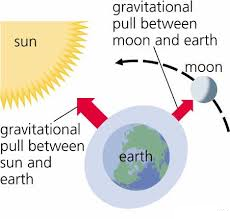
Tides are produced as a result of pull of gravity of the moon and the sun, but the pull of gravity of the moon. Contributes more because of being closer proximity to the earth. The sun’s great mass, however causes it to have an appreciable effect, despite its great distance from the earth. The moon attracts or pulls water to the side of the earth nearest to it. This creates a bulge or high tide.

TYPES OF TIDES
Tides are classified according to:
Their varied degree of tidal range
Rate of occurrence in a day
According to their varied degree of tidal range, tides broadly classified into spring and neap tides.
Spring tide
It is the one with maximum tidal range produced when the moon and the sun are in alignment on the same side, increases gravitational attraction production same side, increases gravitational attraction producing the and lowest low tide. This is also known as syzygy tide in basis that, the position when the earth, the moon and the sun are all in straight line is called syzygy period.

2. Neap tide
It occurs when the sun, earth and moon form a right angle with the earth apex as result, the tidal range is made least, This is also known as quadrature tide, in basis that, when the moon, earth and sun are in such a position that they form right angle with the earth apex is called quadrature period. At this position the moon and the sun are pulling the water on the earth to themselves. The result is that, the force of each body is weakened. The high tide will also be lower than normal
According to rate of occurrence per tidal day, tides classified into the following types
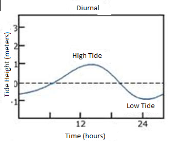
1. Diurnal tides
These are the simplest form of tides characterized by one high water and one low water per tidal day, It is very common in Northern Gulf Mexico and south East Asia
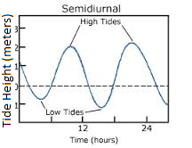
2. 2.Semi diurnal tide
-It is a form of tides, characterized by two high water and two low water per tidal day as the successive high water and low water levels are approximately equal. They occur provides, both the sun and moon are along the equator in a region at varied time per tidal day
3. 3.Mixed tides.
-The form of tides, characterized by having successive high water and low water levels stand differ appreciably i.e. There are higher high water level, and lower high water level as well as higher low water level and lower low water level per tidal day.

OCEAN CURRENTS
-The knowledge of major surface currents comes principally from compilation of mariner’s observation begun in 1840 by the American oceanographer, Mathew Fontanel Maury. It was discovered that, ships courses, are deflected by surface currents. The currents cause discrepancy between ships intended position, and its actual position after it has traveled for a period. With this it was once discovered that, sea surface water have currents. Therefore ocean currents defined as are the movements of surface water masses in the ocean in the ocean basin horizontally covering a considerable distance.
There are two types of ocean currents namely cold and warm currents.
-The cold ocean currents in the world includes; Peruvia, California, West wind drift, Benguela, Canaries, South pacific current, south Atlantic current, south equatorial and Oyashi.
-The warm ocean currents includes; North equatorial currents, North Atlantic drift, North pacific current, Kuro siwo, Mozambique, South Equatorial current, Brazil and Others. The ocean current is produced by the combined factors which are also considered as interplay factors for ocean currents. These include the followings.
1.The world wind belts; the blow of global wind systems over oceans, set up the surface water in motion and thus produce currents. Moreover the directions taken by the wind blow.
2.The temperature of the ocean water; the ocean waters temperature of region produce either cold and warm currents. Cold currents develop in Polar Regions, while the warm currents develop in areas of tropical latitudes.
In Polar Regions the average temperature is around 4
and sometimes is much lower. The water is therefore cooled, descends
and moves towards the Equator at great depths in the oceans. In tropical
regions where the average water temperature is around 26
, the water is heated and expand. Hence ocean water moves away from the area at shallow depth towards the polar.
3.The rotation of the earth; The rotation of the earth exert the force on the earth’s surface which deflects the movements of objects from their normal position to the right in the northern hemisphere and to the left in southern hemisphere. Hence the movements of ocean water surface are also deflected to the right and to the left in the northern and southern hemisphere respectively.
4.The shape of land masses; The shape(angle)of the coastline affect the direction of water current by redirecting it in certain path. Hence the path taken in any particularly current partly depends on the shape of coastline.
SEA LEVEL CHANGE
Sea level change is defined as a variation in the general level of the sea. The average position of the sea in relation to the land has remained relatively constant for the nearly 6,000 years. Before that time, there are had been several changes in the mean sea level. The most dramatic change being as a result of the quaternary ice and plates movement.
Sea level refers to a general level of the sea as if it were influenced by tides of waves.
Sea level changes in classified into
-
Negative changes (negative movements) in which the sea level is falling relative to land level. The coastal land emerges.
-
Positive changes (positive movements) in which the sea level is rising relative to the land level. The coastal land subsides.
Causes of the sea level changes.
1) Glacial formation and melting of ice.
2) The rising and falling of coastal land i.e. Isostatic movements.
3) Eustatic change can also be caused by the change in the size of the ocean basin.
Coastal Scenery resulting from changes in the sea level
Relative move of the sea level can be grouped into negative and positive as mentioned earlier .
-Negative movement produce Emerged coasts
-Positive movements produce submerged coasts
1. SUBMERGED COASTS
-Occurs when highland along/near the coast lines become submerged (sinking of the land).
a) RIA coast
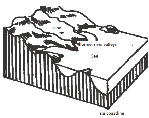
This is the coast which is formed when the highland area with level valleys is submerged and the lower parts of its river valley becomes flooded by water from the sea. The submerged river valleys are called rias, formations of harbors. E.g. Between Sierra Leone and Gambia, coast of guinea Bissau West Africa. Mombasa and Dar coast (harbors)

b) Fiord coast
This is formed when glaciated U-shaped valley are flooded after the submergence of former coastal highland. The flooded glaciated U-shaped valleys are called fiords. E.g. Alaska in U.S.A, South island in New Zealand, Fiord in Chile.

c) Dalmatian/longitudinal coasts
-Coasts formed/found in regions made up of hills and valleys which lie parallel to the coast are submerged. After submerged; – The valleys which are between the mountains are flooded. The flooded valleys are called sounds and mountain ranges become chains of island E.g. Dalmatian coast in Yugoslavia.

Submerged coast in lowland
a) Estuarine coast –flooded parts of river valley at their mouth.
-Formed when the lowland area along the former coast is submerged due to
penetration of water inland after the rise sea level. The submergence
leads to the formation of the feature like estuaries. Estuaries coast
are formed when the river mouth is drowned.


2. EMERGENT COAST
-Form when the lands under water (continental shelves) become dry land by uplift. /formed where there is a relative fall in the sea level leads to emergence of larger part.
Emergent upland (of the continental shelf)
i) Raised beaches – These are the beaches which stand above the present shore line.eg in Mombasa


ii)Wave – Cut Platform:
-These are platform like features standing above the present shoreline.
iii)Notches:
-These are v- shaped cut formed as of undercutting of a cliff during the high tide on the emerged coast.
iv)Old Cliff:
-Is the cliff which stands above the next cliff.
ACCORDING TO STRUCTURE TREND OF LAND
i. CONCORDANT COAST
-Type of coast where by the structure trend of the land is parallel to the coast, in this the highland like mountain and valleys run parallel the direction of the coastal alignment e.g. Dalmatian of Yugoslavia.
ii. DISCORDANT COAST
-Type of coastal where by the structure trend of land is at height angle top the coast. It is mountain and valley running at right angle to coast. Example fiord coast in the Scandinavian
Classification of sea level changes.
-
Sea level change is classified into two basic types according to the causal factors influenced it to occur and include.
i. Eustatic Sea levels change
It is the variation in the general level of the sea taking place at a global level (worldwide) usually caused by either melting of ice or severe freezing of water. Severe freezing of water causes the rise in sea level as more water discharged into the ocean basin.
ii. Isostatic sea level change
-It is the local variation of the sea level caused by he changes in the level of land as a result of earth’s movement. When land rises, sea level falls, and when the land level falls sea level rises.
-
Sea level change is also classified as positive and negative change:
Negative change is the fall of the sea level relatively to the land level while
positive change means the rise of the sea level
EVIDENCES INDICATING THE PAST CHANGE OF THE SEA LEVEL.
1. GEOMORPHOLOGY EVIDENCES
The geomorphology evidences are principally to the features related to submerged and emerged coasts resulting from the rise and fall of the sea level relatively to land level.
The features associated with the submerged coasts include the following:-
(i). Estuarine coast.
It is a low lying coastline with a fully flooded river valley. The feature is produced as the low lying coastline with river valley submerged following the rise of the sea level making the valley of the river fully flooded by the oceanic water.
Where estuarine coast found, it becomes difficult to recognize the levels of the river and sea. The most classic example of estuarine coast in the world is that of Thames coast in England

(ii). Ria coast.
It is highland coastline with a partially flooded river valley. It results where a coastline of high level with river valley submerged as sea level rises making of rises making the lower parts of the valley flooded. Ria coasts are common in SW Ireland, SW England and New Spain
(iii) Longitudinal coast.
It is a coastline lies parallel to the submerged valleys of mountain chain.
Where highland coast whose mountain valleys parallel to the coast, after submergence, the valleys will be flooded and the mountains separating the valleys, become chains of island. A good example of Dalmatian coast, is the coast of Yugoslavia
(iv) Fiords.
Fiord is a long narrow steeply sided and deep sea inlet along the coast. A coast line with this unique feature, is called fiord coast. Fiords were produced by the drowning of glacial troughs after submergence. A good example of fiord is that of also in Norway
The features associated with emerged coastlines include the following
(i) Offshore features like beaches
These were produced after the low land coast to have been emerged. The emerge of the coast makes the features which were along the shore line to appear out of the shoreline as a new shore line formed. Off features are more observed along the Gulf of Mexico.
(ii) Raised features
The features which appear high enough away from the sea. These have resulted after the high land coast to have been emerged. These include mostly the raised beaches. E.g. Raised beach in western Scotland.

2. ARCHEOLOGICAL EVIDENCE
It is much based on Neolithic settlements and Roman pavements in the Southern Sweden, which appear below the present low tide mark.
3. ROTANIC EVIDENCE
It is principally to the finding of peat, formed due to the submergence of forests on the coast of Wirral peninsula nearly Harleth in North Wales.
4. REJUVENATION OF RIVERS AT LOWER COURSE
Most of the rivers at lower courses characterized by having gentle or general level gradient giving to low water velocity. Some rivers have high water velocity which indicates that, the gradient of water flow has increased due to the fall of sea level relatively to the coast land.
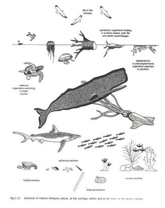
LIFE IN THE OCEAN
Ocean water supports the life of organisms because of its aquatic eminent. The aquatic environments provide organisms with important gases nutrients, food and other important requirements
The organisms found in marine water are of both, plants and animals
Organisms in the marine aquatic ecosystems are of married nature, and also have varied habits. By being varied in such aspects, organisms broadly categorized into the following forms.
According to their habits, marine organisms include the following groups
a. Benthos
These are the organisms living on or in the ocean bottom (benthic environment) some live on bottom sediments. And called in fauna. And others live near bottom water called epifauna. Examples of benthos include; marine warms, mollusks, crustacean, star fish and others. Generally speaking, benthic organism is far more abundant in shallow water than on the deep ocean bottom.

b. Nektons
These are the free swimming animals, they are more abundant in near surface waters, but occur at all depths in the ocean. Many types of nekton organism have regular daily vertical migration, At night they swim to the surface water to feed up on the abundant life in this layer. During the day they return to greater depth where they are more difficult to be seen and less likely to be eaten
Some common nektonic organisms
c.Neutrons
These are the marine organism live at the upper surface layer of the sea. Some live on the water surface, and others live just below the ocean surface neutrons include, Valella, physalia and other related forms of organisms
c. Neutrons
Marine organism according to their varied nature include the following.
1. Plankton
These are the minute pelagic plants and animals that are weak swimmers and can easily moved by currents. Plankton are further divided into:-
(a) Phytoplankton(plant plankton)
There are the minute single called plants. They live nearly to surface in the environment called euphoric zone, because of requiring sufficient sunlight for photosynthesis,
(b) Zooplanktons, (Animal plankton)
These are the animal plankton in the marine ecosystem.
2. Marine mammals.
Marine mammals include: Whales, dolphins, seals, sea lions and others. They are warm boded, breath air and give live birth to their young. These are legless and have streamlined bodies.
3. Sea birds
Sea birds are among of conspicuous and familiar form of marine life. Some spend nearly their entire life in the sea, others can barely walk on land, Some sea birds only use seawater for food. Some fly over the seawater and other swim under water
SIGNIFICANCE OF OCEANS TO HUMAN LIFE
(Positive significance)
i. Manufacture of drugs and other chemicals from marine organisms, Marine organism contain many biologically active compounds, that are potentially useful for medical purpose.
ii. Energy electricity is generated by using the tidal range. The rising and falling of water can be used to generate electricity. E.g. At St. Malo in North west France, The electrical energy is known as tidal power .
iii. Parts of the sea can be reclaimed into new land to accommodate more population and give a room for agricultural and industrial expansion
iv. Many resources are extracted from the sea water, sea water supplies several materials such as fresh water, salts , bromine, and magnesium water evaporates, Eg North of Malindi – Kenya
v. Extraction of petroleum and natural gases. These have been formed by decomposition of the plant materials primarily marine plants. Hence they have been formed by submerged deposits.
vi. Oceans are the source of fish everywhere in the world.
vii. Allow the sailing of large vessels of ships. It saves as an important route way connecting the widely separated parts in the world.
viii. Used as sewage disposal system.
ix. Tourism Oceans provide sites for a variety of recreational activities. These include. Swimming surfing, water skiing, sport fishing, and cruising e.g. tropical seas are a tourist attraction because they are warm all year around.
x. Port development. Some features on the submerged coasts favor the development of deep and well sheltered natural harbors. E.g. Fiord coast in Norway
(Negative significance)
i. Infertile soils. Some emerged coastal lands are characterized by sand, gravel and bare rock, such surface cannot support proper plants growth because they are infertile.
ii. Transport barriers; deposited sands, sandbars and coral reefs are a barrier to water transport, Sometimes, ships have been wrecked after hitting some of those features.
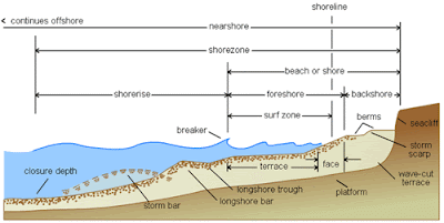
COASTLINES
-Coast refers to the part of the landmass that is situated immediately after the sea. It is separated from the sea by a shore line. Shoreline means, a piece of land that lies in between of high tide and low tide levels.
COAST EVOLUTION
Coast evolution means, the structural change in appearance of the coastline. Usually the structural appearance of coast varies from place to places or time to times. E.g. the structural appearance of Dar es Salaam coast differs from the Bagamoyo. The structural appearance of Dar es Salaam coast currently, is not the same as it was in many years ago. Hence the phenomena of the coast to change in it structural appearance place to place or time to time geographically described as coast evolution
The evolution of a coastline is brought by one or combination of two or more of the following factors.
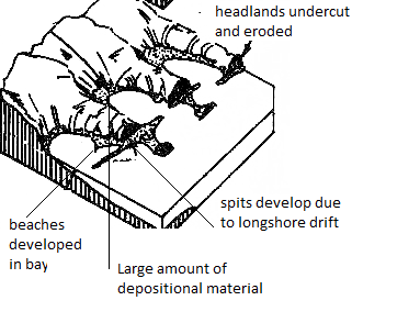
1. Wave action
Wave has a considerable impact to a coastline structural change through the activities of erosion and deposition. Wave erosion may cause a coast line eroded to have features of marine erosion of like; cliff, notch, stacks, bay and others of the same consideration. Wave deposition may cause a coastline developed with features of marine deposition of like; beach, barrier beach, spits, tombolo and others.
2. Tectonic forces.
Tectonic activities have changed and may continue to change the form of appearance of coast lines through uplifting and sinking relatively to sea level. Uplift of a coast line, produces emerged coastline. Down warping produces the submerged coastline.
3. The nature of rocks along the coast
A coastline may change partly because of its nature of rocks along. For instance: the coastline with alternative rocks of hardness, one subjected to erosion, may change into indented coastline as it can be compared to a coastline of uniform rock hardness.
Beside to this, where the coastal rocks are resistant to erosion a highland coast is formed with cliffs.
4. Man activities
Human activities of like land reclaim nation harbors construction, canals construction change the natural appearance of coastlines. For example: the land reclamation in Netherlands, have changed the form of appearance of coasts along the North Sea.
5. Volcanic activities
Eruptions of volcanoes have caused some coasts to change in physical appearance as landforms related to the geological phenomena form along the coasts.
6. Glaciations.
It is considerably on the occurrence of glaciers along the coast. This leads to coast evolution in two varied ways. Firstly; the melting of ice has caused the rise of general sea level, and then made parts of coasts to immerse in water, and thus submerged coasts have been formed. Secondly glacier activities of erosion and deposition resulted into the occurrence of some physical features related to glacier erosion and deposition.
7. Organisms
Marine organisms like coral polyps have caused coasts to change in physical appearance as coral reefs develop along them.
CLASSIFICATION OF COASTS
Coasts are extremely varied due to several determinant factors of like; marine action, organisms, earth’s movements and others. The earth’s scientists have classified coasts according to their varied considerations. The most striking criteria which have been employed to classify coasts include the following.
1. Change in sea level, devoted by Johnson 1919
Neither the level of the land, nor the level of the sea remains unchanged. One of these changed and produced either submerged or emerged coastlines. Considerably to this, coasts are classified into the following forms.
· Submerged coasts
· Emerged coasts
· Neutral coasts
· Compound coasts
Submerged coasts
These are the coast lines whose lower parts immersed in water due to the rise of the sea level.
Submerged coasts are sub divided into two and include;
· Submerged lowland coast
· Submerged highland coast
Lowland submerged coasts form following the fall of lowland coast as the sea level rises. Highland coast produced after the fall of highland coast line due to the rise in sea level.
Emerged coasts.
These are the coastlines that have been produced after the fall of the sea level, and rise of the coastal land. These are also classified into lowland and highland emerged coastlines. Low land emerged coasts are produced after the lower parts of highland coasts to become out of water as sea level falls while the highland coasts are produced after the lower parts of highland coast to become out of water as sea level changes.
Compound coasts.
Those with a mixture of at least two or more of the features of submerged and emerged coasts. i.e. the coastline is observed to have characteristics of both emerged and submerged coastlines.
2. According to the structural appearance relatively to other coastal features
With respect to this consideration, coastlines broadly classified into the following types.
· Discordant coast line
· Concordant coast line
Discordant Coast line
It is the coastline that extends across the trend of the mountain ranges and valleys. Usually the coastline is irregular with many inlets. Discordant coastline has alternative terms of transverse and Atlantic. The later is because such high proportion of this type of coast is around the Atlantic Ocean.
Concordant Coast.
It is a coastline that lies roughly parallel to the mountain ranges and valleys. When such a coast is submerged, produces the Dalmatian coast. A concordant coast is very common in areas of around Pacific Ocean and that is why they are alternatively known as pacific coasts.
3. According to the relationship between coast and other processes of erosion and deposition
This was devoted by Sheppard in 1963. According to the approach, gives two types of coast
Primary coasts
The coasts where the influence of sea has been minimum. The coasts characterized by the presence of features not formed by marine action
Secondary coasts
Where marine processes have been dominant. The coasts are characterized by the presence of the depositional and erosion marine features of like.
4. Advancing and retreating coasts (Valentine 1952)
-It assumes that, a coast can be fitted into two of the following forms.
Advancing coasts
-The coast line that whose level rises as a result of marine deposition or uplift of the land
Retreating coasts
-The coastlines that appear to diminish because of marine erosion or submergence of the coastal land
1.5 CORAL COAST
-It is a coast which is made up of skeleton of the small marine organism is known as coral polyps consist of lime stone rocks resulting from skeleton of marine organism.
-Is a limestone rock which accumulates from the sea to the land.
Coral polyps
– Are living organism found on the marine and live in sheath like sacs composed of calcium carbonate (CaCo3) which they extract from ocean water. Coral:
-Is the limestone rock made up of the skeleton of very small marine organism called coral polyps
Characteristics/coral polyps thrive under this condition.
i. Found in sea temperature around 21oc-30oc
ii. Sediment free salty water
iii. Found in lower tides. Sunlight which penetrate to a depth of at least 50m.
iv. Enough supply of oxygen and food (plankton ) v. Coral features normally develop at latitude of 30N and 30S because of warm ocean currents.
TYPES OF CORAL REEFS
Coral reefs are of various structure and in this basis broadly categorized into three types involving.
i. Fringing
ii. Barrier
iii. Atoll
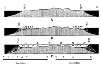
· i. FRINGING REEF: (Connected to coast)
-This consists of a plat form of a coral connected to and built out form a coast. The plate form surface is usually flat or concave and its outer edge sleepily to the sea floor.
-The lagoon is shallow separating the coast and edge of e.g. fringing reef along the coast of the reef Kenya and Tanzania.
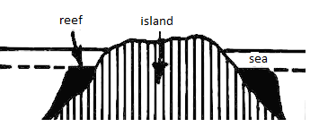


· ii. BARRIER REEF.
– Similar to the fringing reef except that it is located several kilometers from the shore and is separate from it by a deep –water lagoon. The coral of a barrier reef is often joined to the shore, although the lagoon may be too deep for coral to grow on its bed.


A circular coral reef usually broken in several places, surrounding a shallow lagoon.e.g. Aldabra atoll that lies between Zanzibar and Malagasy
It is concave shaped. (atoll formed in deep-sea )

Importance of coral Reefs (value)
i. Provide habitat for fish species and protection
ii. They are used as raw materials in manufacturing of cement in the cement industries (limestone)
iii. They attract tourist and lead to the earning of foreign currency.
iv. They are used as decorations in different building e.g. marble, some well shaped pieces of coral rock are usually stuck on the walls of the building with cement.
v. They also lead to the formation of island which can be used by man for different purpose like settlement or recreation.
vi. They also protect the coast against the strong waves, which can cause coastal land degradation and destruction of property.
vii. Source of income since some people collect coral stone and sell them.
Problem posed by coral reef in the world.
i. They are great barrier to navigation.
ii. Piece of coral rock that breaks during coral quarrying especially by using dynamite and the solution of coral rocks due to the presence of acidic material lead to water pollution.
iii. Coral reef can block the waves and lead to the failure in the formation of attractive beaches.
iv. Coral masses and discourage the growth of plants (sea weed) that tends to pollute, discourage, fishing, swimming and navigation.
CORAL REEFS FORMATION THEORIES
The classification of coral reef theories is divided into two major groups.
i. Those theories which require a change of sea level relative to reef foundation
ii. Those theories that hold that coral reef may develop without a change in sea level relative to the reef foundation.
Under the 1st group;
1. DARWIN`S THEORY
Of sinking land area and consequent rising sea level. Under those condition it is started the corals grown upward and outward converting fringing reef into barrier reef and final atolls.
These depend on the subsidence of land masses. As an island subsides, the coral reef grows upward and outward keeping pace with the subsidence.

2. DALY`S THEORY
– The glacial control theory develops by Daly postulate a rising sea level due to the return of water to the sea following periods of glaciations.
This is based on the changing level of the searching and after the last ice age.
a.
Under the 2nd group;
MURRAY`S THEORY:
– The formation of the barrier reef doesn`t involve subsidence. He argues that coral reefs might have grown as a result of deposition of the coral debris on the seaward sides of the fringing reef. The deposited materials eventually form a base for further growth of polyps.
-The material deposited on the main hills or plateaus reduce the depth of the oceans thus making them sunlight and consequently the condition becomes conducive for polyps habitation. As these polyps die, they lead to the growth of coral reefs.
GLOBAL DISTRIBUTION OF CORAL REEFS
-As it has been already discussed coral reefs are in abundant supply on the esteem sides of the major land masses in the latitudes position in ten teen 30 North and South where sea temperatures reasonably high as warm ocean currents how nearly the coasts.
-The specific areas with coral reef include the following
-Along the edges of continents, E.g Along the edge of Australia where there is the greatest Barrier Reef of the world.
-Around island shores in the pacific ocean e.g. New Guinea and Caledonia
-Around the shores of volcanic peak especially in central and western pacific e.g. Fiji and Samoa islands.
-In the Atlantic Ocean in the west Indian Archipelago where there ia a group o f Island
-Around some islands in the Indian ocean e.g. Mauritius and Seychelles
Significance of coral reef to human being (constructive significance)
-They are used a raw materials to manufacture cement
-They are for building decorations
-They provide attractive sceneries and thus form the basis for tourism.
-Provide good breading stations for fish
-They have resulted into the formation of beautiful islands which used for recreational purposes
-They protect the coasts against erosion by marine waves
Destructive significance
-Coral plat forms encourage the growth of weeds which have a lot of setbacks
-Coral reefs impose barrier to navigation
-Contribute a lot to coast zone degradation because of being exploited
-They impose difficulties in fishing activities
1.6 WATER USES AND MANAGEMENT
1) WATER USES
Water uses understood as the utilization of water resource to meet various needs. Water is our most precious resource. Water is vital to life. Humans, plants, and animals are made up of mostly water. All living things would die in the absence of water.
There many ways that we use our water these include:
-Water is used domestically for drinking, washing clothes, cleaning, bathing, cooking, and other domestic uses. It is estimated that 8% of worldwide water use, is for house hold purposes.
-Power generation; water is used to generate power which supplied to the industries, commercial areas and residential areas. Of all the electricity in the world, about 20% is generated by H.E.P.
-Water is used the manufacturing industries. In manufacturing industries water is used to wash raw materials and for cooling the industrial machines. Moreover, water is heated and steam is used to run machines, in other industries water is used to cool metals. It is estimated that 22% of worldwide water use, is for industries purpose
-Water of larger bodies is used to serve communication. They are used as important route ways to transport people and goods from one area to another. Many people use boats and ferries to commute to and from every day. People also enjoy going on cruise ships or just going sailing.
-Water is also used outdoors for washing cars, watering lawns, filling swimming pools.
-Every town and city, whether small or big, uses water, cities use water for fire fighting street cleaning, and watering public areas such as parks, grass, shrubs, and flowers.
-Recreation is another way that we use and enjoy, Many people enjoy fishing, boating, sailing canoeing, sailing, rafting, and swimming, as well as many other recreational activities that depend on water. However, recreational water use is usually a very small but growing percentage of total water use.
Generally as already pre described water is a vital resource to human life as well as the general ecological system. Thus there is a need for water to be properly conserved and managed.
2. WATER MANAGEMENT
Population growth together with changes in lifestyle and economic development in many countries has heightened the pressure on water resources that are already limited. Moreover, Environmental problems, especially climate change, add to those pressures. Furthermore, poor water management can be a source of conflict. Therefore, water being an essential resource for all life on the Earth planet, there is a need of making sure that, water resources used equitably, by making proper plans on how water can be retained and distributed to meet the numerous demands by people. This is what understood as water management.
Water management is the activity of planting, developing, distributing and managing the optimum use of water resources. In an ideal world, water management planning has regard to all the competing demands for water and seeks to allocate water on an equitable basis to satisfy all uses and demands, In water management much effort is put on optimizing the use of water and in minimizing the ornamental impact of water use on the natural environment.
IMPORTANCE OF WATER MANAGEMENT
i. Water management ensures the supply of water to all people demanding with balance to the needs to industry and environment
ii. It makes restorage and monitoring the amount of water
iii. It ensures water quality and sanitation
iv. To ensure sustainable and fair access to clean water suitable for all purposes, which meets, in particular, the basic needs of the most disadvantaged population
v. To ensure fair and appropriate distribution of water between users of different kinds
vi. To solve the problem of water use conflict
vii. To prevent wastage and pollution of water
viii. To protect the wetland areas
viii. To protect and conserve the water resources areas
METHODS OF WATER MANAGEMENT
There are about four methods for water resources management, They include:-
· 1) Conservation
· 2) Allocation of water charges
· 3) Retrofit water conservation
· 4) Behavioral practices
1. Conservation
-Water can be conserved by harvesting rain water, ground water recharge and recycling waste water.
-Rain water harvesting system involves the collection of water from the surface which directly receives rainfall. The water harvested is stored in tanks or diverged to artificial recharge system.
-Ground water recharge; It is by allowing percolation of water into the ground, this is achieved by planting trees and construction of lakes.
-Recycling of waste water, waste water can be recycled by being retreated with chemicals to become clean and safe for reusage.
2. Allocation of water charges.
-This method is by two system of the following
(i)Ratio utility billing system
Under this system water costs in residential areas like apartments distributed according to each resident based on allocation formula such as number of occupants, square footage, Number of water fixtures, number of bathroom, size of apartment (2bhk, 3bhk) or charge a fixed amount per apartment . However the system has significant disadvantage as residents or consumers won’t understand the true cost or unit of water consumed by their family members
(ii) Sub-metering
A typical sub-metering system consists of a meter to measure usage of a specific utility for each unit and wireless system to transmit the data to a central computer to allow for remote reading. This system enables residents or owners to pay for the water they use rather than paying a fixed amount. For effective water management, this system is recommended as this automatically encourages people to conserve water.
3. Retrofit water conservation
-Retrofitting involves the replacement of existing plumbing equipment with equipment that uses less water.
4. Behavioral practices
-Behavioral practices involve modifying water use habits to achieve more efficient use of water thus reducing overall water consumption. Changes in water use behavior can be implemented without modifying existing equipment. Behavioral practices involve water conservation measures such as replacing or repairing leaky facets. Awareness activities to promote sustainable management of water resources etc.
Implementation approach to water management
Five activities have been identified and are required to achieve integrated management of water resource. They include the following.
1. Awareness and participation. Users must be aware of the importance of water as a resource and their responsibilities in relation to sound management of this precious resource.
2. Institution capacity building. The success of activities depends largely on the capacity, resources and expertise of the instructions concerned. Support must be provided for the institutions responsible for water management. The main institutions for water management include. Urban or municipal water authorities and river basin project institution
3. Demand based management, It is not enough to manage only water distribution; supply must also be managed. The challenge is to reduce demand while increasing output through initiatives as reuse of water, protecting water resources etc.
4. Expanding the knowledge base, the necessary knowledge and information are essential for drawing up effective policies.
5. Coordination among donors must be strengthened
WATER RESOURCES AND MANAGEMENT IN TANZANIA.
Tanzania has great growing demand for water sources. Access to safe water is essential for addressing poverty and health problems. The poor, most of whom live in rural areas, have limited access to clean water for domestic use and crop production and adequate sanitation. Moreover One third of the Tanzania receives less than 800 mm of rainfall and embraced to semi arid areas. Only one third of the rest of the country has precipitation of above the rest of the country has precipitation of above 1,000mm. Also the long dry season normally extending from June to October, has an effect on low river flows and drying of water reservoirs.
In response to such prevalence, there is need for the water resource available in the country to be well managed to assure water supply to people for their varied needs.
Water resources available
-Tanzania has both surface and ground water sources. Surface water sources include; lakes rivers, ponds wetland reservoirs and others
1. Lakes;
-The country has a number of fresh water lake, they include; Victoria, Tanganyika, Nyasa, Rukwa, Natron, Eyasi and Manyara.
2. River
-Tanzania also has a number of rivers which drain into ocean and lakes, They include; Pangani, Wami, Mkondoa, Ruvu, Rufiji, Ruaha, kilombero, Mbarangandu, Matand, Mbwamkulu, Lukuled and Ruvuma all of which drain into Indian Ocean, Others include Malagarasi drains into lake Tanganyika, Songwe and Ruhuhu draining into lake Rukwa; Meri, Maru and Kagera draining into lake Victoria
3. Wetlands:
-Tanzania has 5,439,000 ha, of lakes and swamps which represent 5.8 percent of the total land surface but this number excludes seasonally inundated flood plains.E.g Rufiji,Ihefu,Jangwani in Dar es salaam.
4. Ground water Resources
-Ground water a major source of water for many areas in Tanzania and actually the most viable alternative supplement in the central and northern parts of the country/ the drier regions of Dodoma, Singida, Shinyanga, Tabora, Mwanza, Mara, Arusha coast and Southern Kilimanjaro.
-Most of the water resources in Tanzania are managed by the water projects
RIVER BASIN DEVELOPMENT PROJECTS IN TANZANIA
-River development projects are the schemes which developed for different purposes. They are established to meet a number of goals such as floods control, water supply for domestic consumption, industries and irrigation schemes
River basin projects are implemented by doing the following:–
-Construction of dams for retaining water
-Dredging of the river i.e Removal of silts or mud from the river
-Clearing of vegetation where economic activities are taking place
-Planting of trees on the sides of the river so as to prevent erosion and to control the speed of water flow.
-Straightening and widening of the river width so that it can hold more water
-Establishment of canals and installing of pipes to make distribution of water
1. KILOMBERO IRRIGATION SCHEME
Kilombero irrigation scheme is located along river Kilombero in Southern Tanzania which is a tributary of Rufiji river. The scheme has large plantations of sugarcane owning to a size of about 2800 hectares, under the schemes other crops such as maize, rice, beans and vegetables are grown.
Objectives of the scheme
-To improve crops production of sugarcane as the chef crop and other crops of maize, rise, beans and vegetables
-To open up the remote and potential lands be used for crops production
-To control the floods of river Kilombero
Implementation of the scheme
The scheme has been implemented as the following were done
-Establishment of the sugar cane estates
-Establishment of the sugarcane factories at Msolwa and Ruembe.
-Small scale farmers were allowed into the area to cultivate sugarcane and other crops
-Establishment of roads to enhance production of crops
-Supply of electricity to the factories and to the site machines which pump water to plantations.
-Establishment of the sugar cane production company to make overall management
-Construction of dams for retaining water to be used all the year around
-Training of the local people on their economic activities like fishing, timber production and wild life conservation.
Achievements of the scheme
-It has increased the production of sugarcane as it can be compared to the previous time
-Development of certain towns like Makambako, Mikumi and Kidatu which provide services to the people working into the scheme
-To some extent, the schemes managed to control the floods of the river as much of the water used to irrigate the farms
-It has stimulated the development of the physical infrastructures like roads and railway of TAZARA
-The scheme has opened up the remote areas like Ifakara and Msolwa.
Challenges against the scheme
-The problems of drought in same years. This creates low water supply to the scheme
-Transportation problem since the road and bridge have not been well constructed
-Poor labor supply due to the higher rate of rural to urban migration
-Prevalence of diseases mostly malaria which affect the farmers
2. THE RUFIJI RIVER BAISN DEVELOPMENT (RUBADA)
-Rufiji basin is one of the most potential areas in Tanzania. It has great river of Rufiji which steadily flows throughout the year, It has attractive features such as waterfalls, meanders, alluvial fans, delta and oxbow lakes, The valley of the river is very fertile for cultivation of crops. It has diversity of flora and fauna. By being so much potential efforts are taken to make the river basin well developed. To meet this, river basin development association of RUBADA, has been established.
Activities taking place in the basin
-Generation of hydro electricity at kihansi
-Fishing activities under the local people
-The cultivation of the crops such as sugarcane, paddy, maize and vegetable
-Tourism is taking place in the sellers game reserves
-Hunting of the wild animals bye ht local people
-Lumbering is taking place by the local people
NOTE
Even if special organization has been established to develop the basin yet the Rufiji basin is not well developed due to the following problems
-Frequent floods which affect the crops and people properties
-Poor market by the local people. A good number of the inhabitants are low income earners and thus do not provide steady markets for the goods that would be produced.
-Remoteness of the river. For instance the river is not utilized to supply water to the big city of Dar es salaam by being in a remote site.
-Poor capital outlay to be invested to the basin
-Poor labor supply due to the higher rate of rural to urban migration
· -Low level of technology.
3. KAGERA RIVER BASIN PROJECT
-The project was established in 1977 by three countries of Tanzania, Burundi and Rwanda, Uganda joined later in 1981. The project was established with found mental objective of establishing Hydro electric power station at Rusumo falls.
Achievement of the project
-Production of the hydroelectricity for the member countries and even he neigh boring countries.
-It has provided employment to people in the four countries.
-Development of transport infrastructures in the region.
-Development of tourist industry.
Problems incurred in the implementation of the project.
-Low level of technology in the region.
-Low capital outlay to finance the project effectively.
-Land alienation to give room for the expansion the project.
-Political conflicts in Rwanda, Burundi, and Uganda.
-The researches and preliminary plans are taking too long.
WATER POLLUTION
-Water pollution is the contamination of water bodies such as lake, river, oceans and ground water. Or is an environmental pollution problem of a water body being contaminated with hazardous solid, liquid and gaseous materials which affect its natural setting. i.e. a body of water is adversely affected due to the addition of large amount of materials to the water. In other words, Water pollution is considered when the body of water is unfit for its intended use.When the body of water is unfit for its intended use.
-Water pollution is among of the serious environmental problems and it is serious enough in developing countries. It affects organism that live in the water bodies.
-Water pollution occurs when pollutants discharged directly or indirectly into water body system without adequate treatment to remove harmful constituents.
-Water pollution may occur naturally or culturally, naturally is by materials of dust which added to the water through the natural processes of wind erosion and deposition. Culturally by the households, industries, mining and others.
The materials which make water adversely affected are known as water pollutants.
Types of water pollution
Water pollution is of two varied forms including; Surface and ground water pollutions
Surface water pollution is pronounced if water contained over the earth surface of lakes, rivers and lakes contaminated with pollutants.
Ground water pollution Occurs when water contained into the ground contaminated with harmful materials which brought down by the process of leaching.
Source of water pollution
As it has been introduced, water pollution occurs culturally and naturally as harmful materials discharged into the water body systems by following sources
1. Agricultural activities
The agro chemicals such as fertilizers, insecticides, herbicides and others, washed away in solution into water body systems by runoff. Also the agro chemicals cause the ground water polluted through leaching process.
2. Households sewage
Residential areas produce a lot of sewage that mostly cause water pollution. The sewage contain farces, urine, and laundry wastes all of which are organisms which live in the systems of water body
3. Damping of littler
If litters derived from varied, sources damped into seas, lakes as well as rivers, cause water pollution. The litters as damped into water bodies take long time to degrade, these include the following
· Call board: They take 2 weeks to degrade
· New papers: take 6 weeks to degrade
· Foam: take 50 years to degrade
· Aluminum: take 200 years to degrade
· Plastic packaging take 400 years to degrade
· Glass: Take long to degrade but the exact time not well known
4. Industries
Industries is a huge source of water pollution, Industries produce pollutants that are extremely harmful to people and environment and thus, cause pollution as discharged into the water body systems without adequate treatments. The common pollutants which cause water pollution include asbestos, leads, mercury, nitrates, phosphate, sulfur, oils, petro chemicals and others
5. Commercial activities
Commercial activities particularly in town centers produce a lot of solid and liquid wastes, Most of these wastes discharged into large water body systems and cause pollution
.6. Mining activities
Water used to wash the minerals usually discharged into water bodies’ e.g the Kiwira river (Mbeya Tanzania) is seriously polluted with the liquid wasted from Kiwira coal mines.
7. Oil spill
Ocean lakes and rivers are polluted with oil spills on a daily basis from motor vehicles, routine shipping, runoffs, dumping, oil underground storage linkages and others. Oils cannot dissolve in water and thus form a thick shade in the water, This suffocates fish and other aquatic life
8. Occurrence acid rains
In the atmosphere water droplet mix with pollutant gases of sulphur dioxide, carbon dioxide and nitrogen dioxides to form acidic rains. These as fall on the surface of water bodies’ causes pollution.
9. Global warming
This causes an increase in water temperature, it can results into health of many aquatic organisms.
`10 Radio activity element
These are the nuclear wastes produced from industries, medical, and scientific processes that use radio activity materials, these materials have detrimental effects on marine habitats.
EFFECTS OF WATER POLLUTION
Water pollution has great impact to people and environmental in general in number of ways
1. Water pollution affect human health
Some health effects recognized immediately, while others take time to be recognized as may take months or years. People use to suffer from water borne diseases as parasites and other diseases causing organisms are transmitted via the contaminated water. The common diseases include typhoid, intestinal parasites, amoebas, cholera, and poor blood circulation, vomiting, diarrhoea nervous systems damages. Heart and kidney injury, skin irritation and tooth decay
2. Water pollution affects the aquatic ecosystems.
Pollution caused by acidic rains, oils and others sources harm greatly the life in water body systems. It makes animals as well as plants adversely affected to the extent others parish completely.
3. Water pollution affects the chain of food
The toxic contained in water travel to animals mostly fish, then travel to human as eat meet. The first international scare related to toxic chemical in the water occurred lake in the 1950 when large number of people in Minamata bay Japan, began to contract an usual disease. Research revealed that, they were buffering from mercury poisoning as a result of wastes that had been discharged into water ways and ingested by fish that had been discharged into water ways and ingested by fish that were eventually consumed by human beings.
CONTROL OF WATER POLLUTION
Water pollution problem can be controlled by the following measures
(i) Sewage’s and others wastes should be treated before are discharged into water body systems.
(ii) People should be educated in such a way can be aware with the bad effect of water pollution and on how to control water pollution.
|
Latitude (North and South) |
Average temperature |
|
Equatorial region 20° 40° 60° Polar region |
20°C 23°C 14°C 1°C |

No comments:
Post a Comment